Greenholme, Burley in Wharfedale
Brief history of the people who transformed "Green Holme" from fields to the textile manufacturing centre of Greenholme Mills.
This is on-going research (& page layout), if you can help with any aspect of it, please get in touch via the contact form.
This is on-going research (& page layout), if you can help with any aspect of it, please get in touch via the contact form.
Greenholme Old Mill, a timber weir, embankments and the first goit was built by a group of four partners: George Merryweather, Jonas Whitaker, Richard Paley & Thomas Davison in 1790-1792. The mill took raw cotton & converted it into cloth.
Research questions: Why site a cotton mill at "Green Holme"? What was there in c1790 to persuade the partners that this was a good place to build?
Possible answers could include:
1. The fall of the river across this section of the valley.
2. Local knowledge: one of the original partners, George Merryweather was renting Burley Hall in 1790. He then married Mary Whitaker (sister of Jonas Whitaker) in 1793 & they were still there when all the lands etc of Burley Manor was put up for sale in 1795.
3. It was the last place on the River Wharfe that could be used. Both upstream & downstream all other possible mill sites had been taken up.
What did the partners need to construct?
Was the horse-shoe shaped bend in the River Wharfe already there or did they create it?
Was the horse-shoe shaped bend in the River Wharfe already there or did they create it?
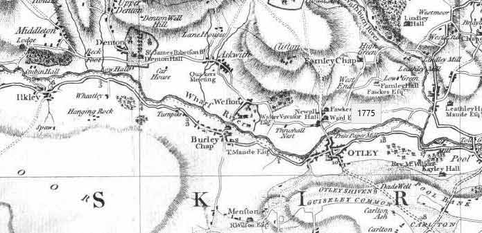
1775 Jefferys map - Wharf River & Burley. Image courtesy of Burley Archive.
The Jefferys maps of Yorkshire from 1771 and 1775 don't show the marked loop of the River Wharfe at Greenholme that we see today.
Was the first mill (Old Mill) built on the 1790 line of the river? The river was then canalised (i.e. the goit) & raised embankments on both the south bank & north bank built, a timber weir was then constructed upstream to make use of an old river channel (i.e. the loop) to act as an overflow channel (now the current river alignment).
This is a time near the end of the age of canal building where digging channels, changing courses of rivers, building embankments etc., is child's play for the civil engineers of the day.
On both the 1851 and 1934 OS maps there's an undefined boundary that runs through Brown's Holme. Boundaries tended to follow rivers, that suggests that the river is in a different place now than it was when the boundary was made.
In addition could anything be said about the contours marked on both maps?
The 200ft contour exactly matches up with the top of the stone weir & follows the top of the south bank & the sides of the tail race of New Mill. The 225ft contour passes diagonally across Greenholme from Wharfeside to New Mill.
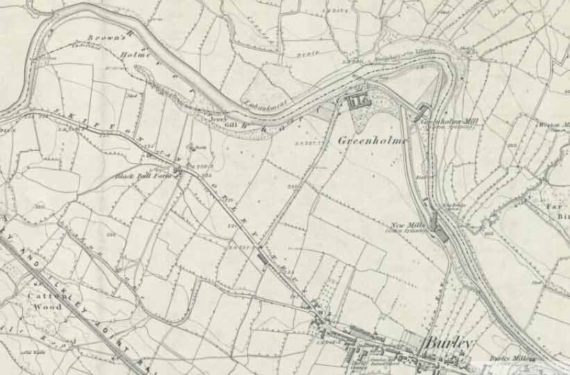
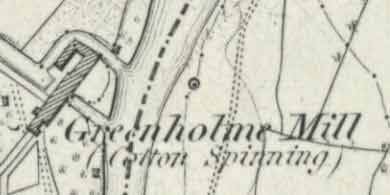
Greenholme 1851 OS Map. Image courtesy of the NL Scotland.
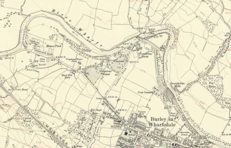
Greenholme 1934 OS Map. Image courtesy of the NL Scotland
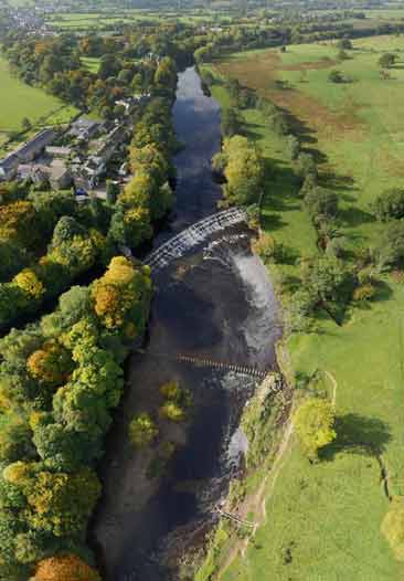
An unusual view below of Greenholme & the River Wharfe courtesy of Houseprices.io The image uses Lidar data from the Environment Agency.
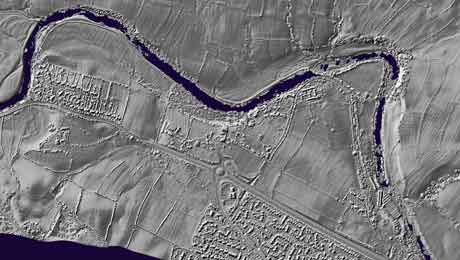
River Wharfe at Greenholme - Lidar 1m DSM Data. Image courtesy of https://houseprices.io/lab/lidar/map
The embankments on both the north & the south bank upstream of the weir, show up really well on this image. The old line of the river through Brown's Holme, likewise.
Greenholme Weir, Sill, Stilling Pool & Stones
The first weir was built in 1790 and made of timber.
According to the account of Henry Whitaker (son of Jonas Whitaker) in his diary printed in 1889 - "I well remember the old weir at Greenholme. The top or upper part of was made of strong planking, and this was propped by substantially-made beams. Over this planking the water fell a distance of 3 or 4 feet on to an inclined stone platform, which sloped down to a square wooden sill made of strong balks, and extended across the river. From these balks there was a drop of about a foot or eighteen inches into a deep pool ..."
According to the account of Henry Whitaker (son of Jonas Whitaker) in his diary printed in 1889 - "I well remember the old weir at Greenholme. The top or upper part of was made of strong planking, and this was propped by substantially-made beams. Over this planking the water fell a distance of 3 or 4 feet on to an inclined stone platform, which sloped down to a square wooden sill made of strong balks, and extended across the river. From these balks there was a drop of about a foot or eighteen inches into a deep pool ..."
In the winter of 1814-1815 the upper part of the timber weir was washed away by a combination of ice & high river levels.
Hiram Craven (1779-1842)(Craven, Whitaker & Nowell partnership - Samuel Whitaker (c1783-1821), Joseph Nowell (1784-1836)) were contracted to build a new one.
Second weir 1816-1817 made of stone.
Construction of a stone weir (or stepped spillway) & its apron, began in the summer of 1816 & was completed in the spring of 1817. The stone was quarried from Burley Moor around Coldstone Beck above Burley Woodhead. This curved stone spillway is the one we see today.
Across the top of the weir were fixed a series of boards, these were raised at times of low flow to maintain the river height through the goits (see below).
Concrete Sill & Stilling Pool
About 50 yards downstream a concrete sill (or mini weir) was built at the same time as the main weir & its apron. This was constructed across the full width of the river, to create a stilling pool, to protect the apron from scour & erosion. The deepest part is near the north bank.
[Note: The stilling pool or "the deep" as its locally known, is the most dangerous place to swim at Greenholme. The currents created will hold even the strongest swimmer under water.]
It was a number of years later when it was discovered by the mill owners, that at times of high flow or flood conditions that the sill was indirectly the cause of increased erosion of the north bank.
To reduce this erosion the solution was:
a) Bank armour
Large blocks of stone were concreted together around the end of the sill down to the ford & laid around 20ft up the bank.
The bank armour was extended downstream on both banks as several courses of stonework - around the loop, incorporating the second mill & the outfall from its goit & onwards along Burley Holme. It reached nearly to the Burley & Menston sewage works.
2012 North Bank Armour & Stepping Stones at Greenholme. Image courtesy of Google
b) Cut-water stones aka the Stepping Stones
These were laid, to be underwater, along the top of the sill to redirect the flow of water back to the centre line of the channel.
When Greenholme Mills was working & drawing water from the river the flow over the stones could be so low that the locals used them to cross the river. In time they became an accepted way of crossing the river & officially a Right of Way from the 1960s onwards. (In addition there is bridleway via a ford that is around 50 yards downstream).
[Note: The mills didn't divert all the water, all of the time. Though the New Mill was the largest water powered mill in England, it was never wholly reliant on the river for power. Over the years they had a fine collection of standing steam engines.]
The River Wharfe on this stretch is known for its gravels. Gravels and water wheels or turbines don't mix well nor do they have a beneficial effect on masonry. To maintain equipment & the goits, the weir boards were dropped, the sluice gates closed & the by-pass channel within the mills was opened to allow the water to escape back to the river.
This meant the full flow of the river would return to the main channel. The sill, the stones, the stilling pool & the north bank armour would then come into their own protecting the apron & the weir from scour & erosion.
Regular Maintenance of the Gravel Bar
A temporary gravel bar is a natural feature of this section of the River Wharfe. Its created by the irregular flow of the river across the weir & cut-water stones. At times of high flow or floods, the river would remove the gravel bar & prevent build up of gravels around the stones. The bar becomes a problem when vegetation is allowed to build up on it & fixes it in place.
[Note: The removal of the trees & their roots, from what is now an island, would enable the river to return to the way it was when the mills were in use. The river could use the full width of the channel & the stepping stones crossing would be available more often throughout the year.]
1949 Ilkley Urban District Council (UDC)
In 1949 Ilkley UDC decided to "improve" the stepping stones crossing. They clearly didn't know what they were for & proceeded to rip the originals out & replace them with large blocks of stepping-type stone.
(In the image from 1949, some of the bank armour can be seen in the background).
The owners Wm Fisons & Co Limited of Greenholme Mills took out an injunction to stop them. Ilkley UDC lost the case & were forced to return the site to how they originally found it.
(In the image from 1949, some of the bank armour can be seen in the background).
The owners Wm Fisons & Co Limited of Greenholme Mills took out an injunction to stop them. Ilkley UDC lost the case & were forced to return the site to how they originally found it.
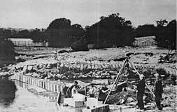
1949 Ilkley UDC Improvement of the Stepping Stones at Greenholme. Image courtesy of Burley Archive
The problem is did Ilkley UDC actually return the cut-water stones to how they were?
In the Burley Archive we have a number of images of the stones that pre-dates the 1949 image. The stones are large rectangular blocks which appear to be much bigger in depth than the ones we see today.
Also, that in preparing the sill to take their stepping stones, did Ilkley UDC lower the height of the sill? Did they rebuild the sill to its original height when told to restore the stones?
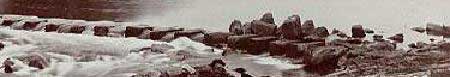
Cut Water Stones at Greenholme. An early postcard. Image courtesy of Sally Gunton
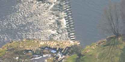
Greenholme Weir, stilling basin & cut-water stepping stones on River Wharfe. Image courtesy of David Bond.
Greenholme Weir Boards
Greenholme weir boards early photo. Image courtesy of Sally Gunton
Weir boards raised at Greenholme, Burley in Wharfedale. Image courtesy of Sally Gunton
To raise the river level during times of low flow, a series of weir boards was raised along the top of the weir. The boards were made of planks of wood connected by wrought iron.
The single board illustrated below & its wrought iron attachments measures about 1.8m x 0.5m & is about 12cms thick. Exactly how many boards there were & what mechanism was used to raise (& lower) them into position is unclear at present.
The single board illustrated below & its wrought iron attachments measures about 1.8m x 0.5m & is about 12cms thick. Exactly how many boards there were & what mechanism was used to raise (& lower) them into position is unclear at present.
Greenholme Weir board propped up at Burley in Wharfedale. Image courtesy of Alex Baxendale.
A few years ago a local resident, Alex Baxendale, managed to retrieve one of the boards from the River Wharfe. The board is now in the possession of Burley Local History & Archive Group who are now looking for help to preserve & display it. If you can assist them please use the contact form. As a temporary measure the weir board can be seen in the corridor at the back of the main room of Burley in Wharfedale Library.
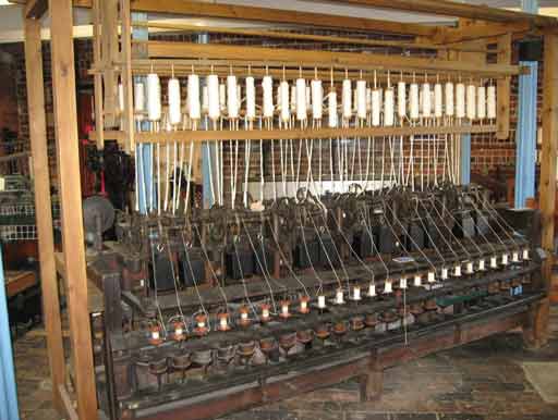
Research question: Textile History
Inventions in spinning & weaving that transformed a cottage hand spinning & weaving industry into an industrial factory process.
1738 Flying Shuttle by John Kay.
Drop Box by Robert Kay.
Spinning by Rollers by John Wyatt/Lewis Paul - predates Arkwright by 30 years.
1738 Flying Shuttle by John Kay.
Drop Box by Robert Kay.
Spinning by Rollers by John Wyatt/Lewis Paul - predates Arkwright by 30 years.
1764 Spinning Jenny by James Hargreaves.
1768 Water (Powered) Spinning Frame by Richard Arkwright.
Sir Richard Arkwright. Image courtesy of the History of Cotton Manufacture - archive.org
Arkwright Water Frame. Image courtesy of North Mill, Belper.
1779 Spinning Mule by Samuel Crompton.
1785 Powered Weaving Loom by Edmund Cartwright.
1785 Powered Weaving Loom by Edmund Cartwright.
The Greenholme Mills Buildings
1790 - 1792
First cotton mill (Old Mill), timber weir & first goit constructed.
The mill was 5 storeys high (105ft long x 28.5ft wide) with the mill leat/goit passing through the centre of the main building.
A breast shot water wheel was housed in the basement (16.5ft in diameter & 14ft wide).
The wheel had a fall of 13ft.
Thomas Lawson (b1754), a clockmaker (mechanic) from Keighley was hired to install & maintain the equipment of the cotton spinning mill. He left in 1803.
1851 OS Map shows the Old Mill at Greenholme, Burley in Wharfedale. Image courtesy of NL Scotland.
1803-4
6-storey workshop and smithy were added.
6-storey workshop and smithy were added.
1808 - 1811
The second cotton mill built, also of 5 storeys & called New Mills (Greenholme Mills). The building was 221ft long x 34ft wide.
The second cotton mill built, also of 5 storeys & called New Mills (Greenholme Mills). The building was 221ft long x 34ft wide.
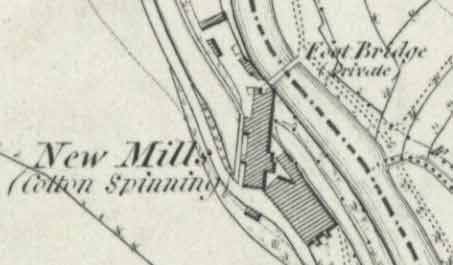
New Mills Greenholme (Cotton), Burley in Wharfedale. OS Map 1851. Image courtesy of NL Scotland.
1925 Greenholme Mills & Goit. Image courtesy of Sally Gunton
A new goit was built as a branch of the first & had a breast shot water wheel, 22ft diameter & 18ft wide, with a fall of 19ft.
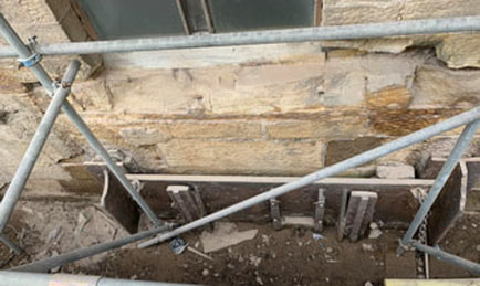
Mill G (Greenholme Mills) - 2020 Goit opening in external wall. Image courtesy of J Godsland
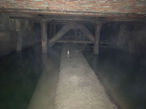
Mill G - Greenholme Mills, Burley in Wharfedale 2020 - Goit under mill. Image courtesy of J Godsland
Mill G - Greenholme Mills, Burley in Wharfedale 2020 - Outfall Goits. Image courtesy of J Godsland
Housed 7,168 throstle spindles (compared with the 2,304 still running in the Old Mill).
This mill also had a Boulton & Watt steam engine, used to power the machinery & the steam was also used to provide heat for the building via the hollow cast iron columns that supported the structure.
c1820 Both the Old Mill & the New Mills were lit by coal gas using Boulton & Watt equipment.
This mill also had a Boulton & Watt steam engine, used to power the machinery & the steam was also used to provide heat for the building via the hollow cast iron columns that supported the structure.
c1820 Both the Old Mill & the New Mills were lit by coal gas using Boulton & Watt equipment.
1825 - Power loom shed built alongside the Old Mill. Contained 108 looms.
1835 New Mills
A new cast iron water wheel installed in the basement of 30ft diameter by 18ft wide (300hp) manufactured by Wren & Bennett of Manchester.
A section of the rim of this water wheel is displayed in the Bradford Industrial Museum - see photo.
A new cast iron water wheel installed in the basement of 30ft diameter by 18ft wide (300hp) manufactured by Wren & Bennett of Manchester.
A section of the rim of this water wheel is displayed in the Bradford Industrial Museum - see photo.
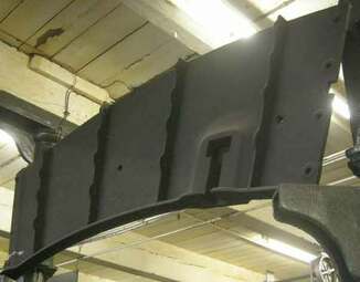
Wren and Bennett 1835 casting for Greenwood & Whitaker, Greenholme Mills, Burley in Wharfedale. Image courtesy of Graces Guide.
1849 - 1852
Both mills & the Greenholme Estate bought by Wm. Fison & Co. from Bradford and converted to worsted spinning & weaving.
Both mills & the Greenholme Estate bought by Wm. Fison & Co. from Bradford and converted to worsted spinning & weaving.
1872
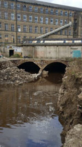
Parts of the New Mills were demolished & replaced with a much larger mill on the same site. The power for the mill came from the Wren & Bennett water wheel of 300hp , a water turbine of 200hp & a steam engine of 200hp. This mill is the one we now call Greenholme Mills.
Parts of the New Mills were demolished & replaced with a much larger mill on the same site. The power for the mill came from the Wren & Bennett water wheel of 300hp , a water turbine of 200hp & a steam engine of 200hp. This mill is the one we now call Greenholme Mills.
Plan of goits under Greenholme Mills, Burley in Wharfedale. Image courtesy of J Godsland
c1880s
Hydraulic power installed for a range of hoists and cranes.
This consisted of an accumulator or cylinder weighing 40 tons which exercised a pressure of 800lbs per square inch on water conveyed in strong pipes throughout the works. Whenever a hoist or crane was set in motion, the accumulator would begin to fall. Automatically a steam engine called "Sisyphus" would start & force it up again.
1889
Electricity for lighting was installed. It consisted of two circuits.
The main circuit was driven by two steam engines "Edith" & "Dorothy", each of 500hp, which actuated three Crompton Dynamos. Two dynamos were used together, the third acting as back-up. The main circuit lit the working rooms & only operated during working hours.
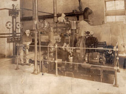
c1890 Greenholme Mills dynamos. Image courtesy of Burley Archive
c1890 Crompton dynamo, steam driven. Image courtesy of claymills.org.uk
Steam driven Crompton dynamo c1890. Image courtesy of claymills.org.uk
The secondary circuit lit the offices, staircases, passages etc. This "Pilot" circuit was completely independent of the main one. It was driven by two more steam engines called "Fulmen" & "Lucifer". The works were lit by 1300 lamps.
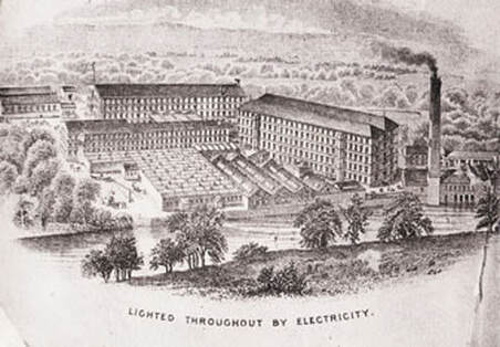
1889 Greenholme Mills Lighted by Electricity. Image courtesy of Burley Archive
1891 - 1892
A new weaving shed was constructed.
A new weaving shed was constructed.
A Mac Adam Brothers water turbine was added to supplement the power for the machinery.
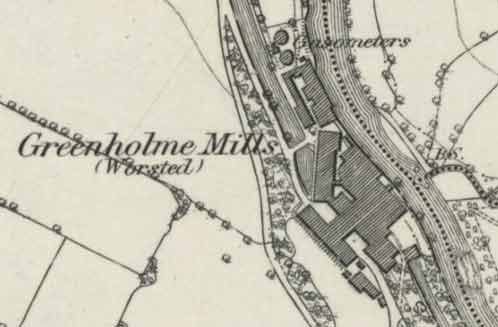
Greenholme Mills, worsted, Burley in Wharfedale. OS Map surveyed 1891. Image courtesy of NL Scotland.
1895
Erection of new wool warehouse, engine house, boiler house, chimney & entrance lodge (gatehouse).
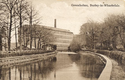
Undated Aerial View Greenholme Mills. Image courtesy of Yvette Horton
1895 construction gate house Greenholme Mills, Burley in Wharfedale. Image courtesy of Thomas Arnold-Forster
Greenholme Mills Gatehouse or Entrance Lodge. Image courtesy of Burley Archive
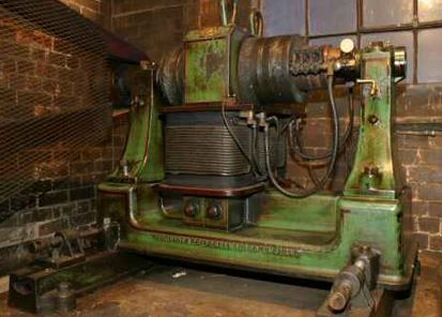
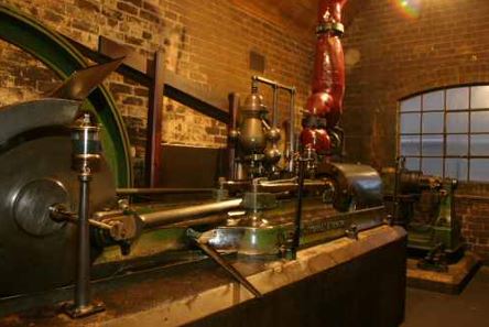
The large water wheel & the Mac Adam turbine in the New Mills were replaced by two 42 inch Hercules Turbines of approximately 250hp each & one Hercules Turbine of 48 inches of approximately 310hp. The fall was 21ft.
These turbines were still in-situ in 2020.
In the case of low water two steam engines were employed to supplement the power. They went by the names of "Victoria" & "Iris".
Victoria, for its part, could be coupled with either one or two of the turbines even while they were running at full speed.
Victoria, for its part, could be coupled with either one or two of the turbines even while they were running at full speed.
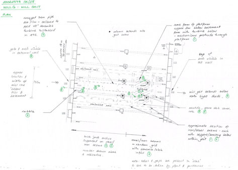
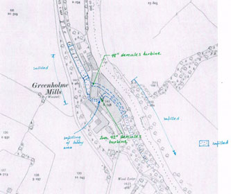
Mill G - Greenholme Mills, Burley in Wharfedale - Goit and Turbines layout plan. Image courtesy of J Godsland
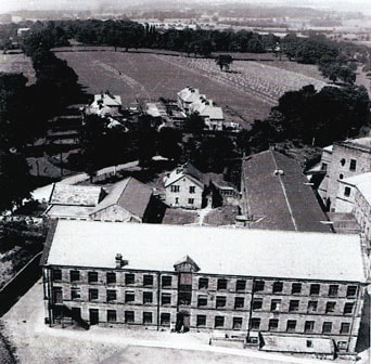
The Old Mill (or the north end of it) was still in use up to the early part of the 20th century as remnants of it are still marked on an OS Map of 1899.
This northern end of the Old Mill was 27.5ft long by 28.5ft wide of 5 stories high. It originally contained the boiler for warming the works, the overlookers departments & lodging rooms for the accommodation of 142 apprentices.
The Old Mill was finally completely demolished in 1976.
This northern end of the Old Mill was 27.5ft long by 28.5ft wide of 5 stories high. It originally contained the boiler for warming the works, the overlookers departments & lodging rooms for the accommodation of 142 apprentices.
The Old Mill was finally completely demolished in 1976.
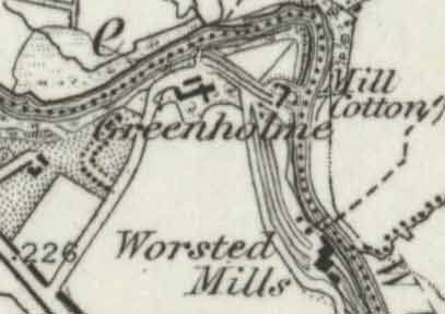
Greenholme Burley in Wharfedale. OS Map 1899. Image courtesy of NL Scotland.
Greenholme Estate
The original Greenholme Mills partnership of Merryweather, Whitaker, Paley & Davison acquired just 20 acres of land at Green Holme c1790. It would have included both sides of the River Wharfe where the weir was sited. They bought the land freehold from Sir James Ibbetson (1746-1795)(Denton Hall).
To expand their activities they would have needed to acquire more land.
In 1795 George Merryweather was renting Burley Hall.
It & the rest of the Manor of Burley was put up for sale by auction by Thomas Pulleyn Mosley, who was in desperate need of finance to fund his "extravagant" lifestyle. [Pulleyns of Yorkshire - archive.org]
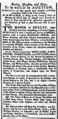
1795 Auction Sale of Burley Manor, Burley in Wharfedale. Image courtesy of the BNA.
According to the auction notice printed in the Leeds Intelligencer July 1795 Burley Manor consisted of:
"comprising with other rights, the Royalty over a considerable extent of Moors, together with a capital mansion house, with barns, stabling and other suitable conveniences, pleasantly situated upon the River Wharfe, now in the occupation of Mr. Merryweather; adjoining to the Mansion is a valuable wood, which extends to the river, and exclusive of its value, renders the situation extremely pleasant and desirable.
Also several convenient messuages, farmhouses, homesteads and cottages, situate in the town of Burley, in the several occupations of Thomas Maude Esq; Thomas Hodgson, John Simpson, Joseph Stead, John Wood, Richard Whitehead, Samuel Rhodes and William Dibb; and also upwards of 391 acres of rich arable, meadow and pasture or grazing land, a considerable part of which is tythe-free, and adjoins upon the River Wharfe.
The Mansion may be accommodated with a convenient portion of land, if agreeable to the persons who intend bidding at the sale, and is an eligible country situation for a genteel family.
The water-side land lies near the township of Otley, and is extremely desirable for the manufacturers or graziers of that town or neighbourhood; and the remainder of the estate is capable of being laid out into considerable or small farms, with convenient homesteads to each."
The outcome of the auction was a break up of the Manor of Burley.
The new owner of Burley Hall was Matthew Wilson (1730-1802) of the Manor House in Otley, who then sold it on to a relative the Rev. Thomas Fourness Wilson (1769-1837). They retained the rights & royalties to most of Burley Moor, Burley corn mill & Burley Holme (the fields that stretch along the River Wharfe from Burley Hall towards Otley).
The rest of the estate including the properties (primarily on Main Street), farms & lands of Burley in Wharfedale & the wood adjoining Burley Hall was bought by the Greenholme Mills partnership.
"Greenholme" - Palladian Mansion or House or Villa, Burley in Wharfedale
The grand palladian mansion was constructed in 1819 to 1820 for Jonas Whitaker & his family. This was in essence a very large extension of their original home which was part of the complex of buildings that included Greenholme Farm & the Greenholme Cottages.
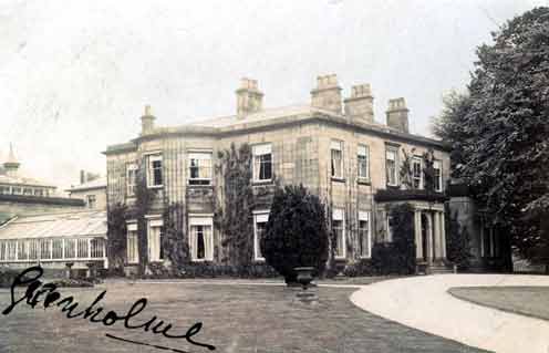
"Greenholme" - Palladian Mansion, Burley in Wharfedale. Image courtesy of Burley Archive.
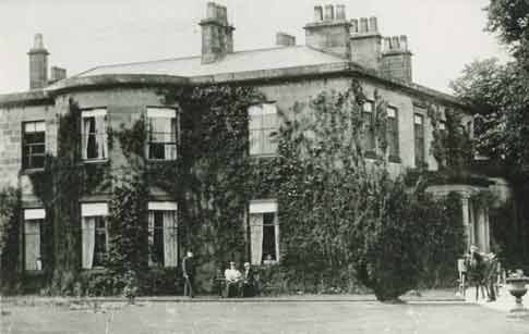
Greenholme Mansion, Burley in Wharfedale. Undated image courtesy of Burley Archive.
1910 plan of "Greenholme" Mansion
At the time of this refurbishment, which included new drainage, Arthur Greenwood (1845-1910) of Greenwood & Batley was renting the property from the mill owners, Wm Fison & Co.
E. Jeffreys Esq was the estate manager acting for the firm.
E. Jeffreys Esq was the estate manager acting for the firm.

(Edward Homer Jeffreys was elected a member of the Institution of Mechanical Engineers in 1882).
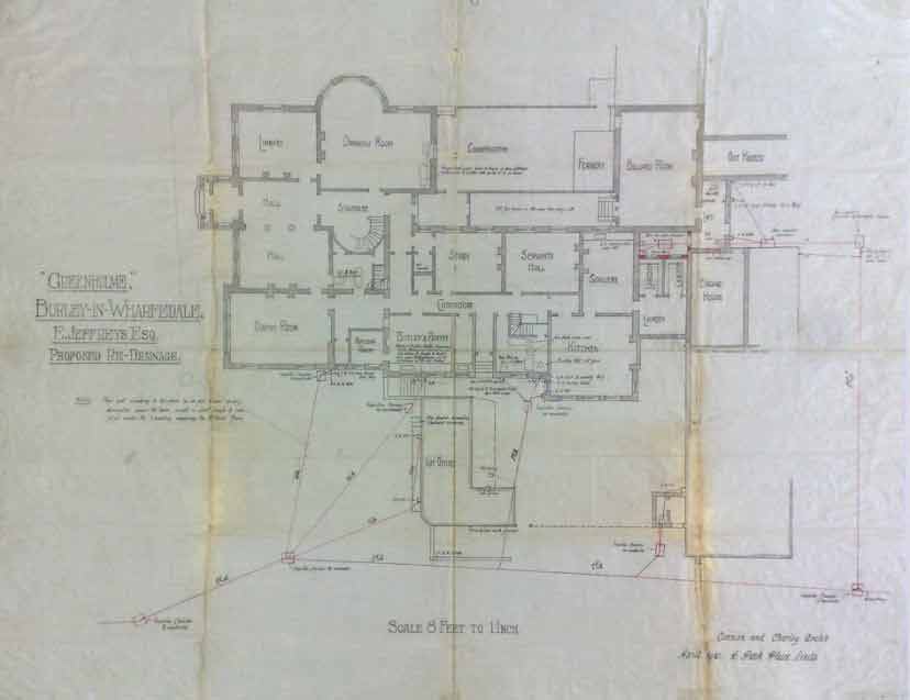
Greenholme Palladian Mansion 1910 plan for refurbishment. Drafted by Connon & Chorley architects Leeds. Image courtesy of Burley Archive.
The plan was drawn up by Connon & Chorley, architects of Leeds. (Harry Chorley & his wife Mary Chorley were residents of Burley Woodhead). The plan is drawn with South at the top, North at the bottom.
The plan itself was donated to the Burley Archive by Mrs Taylor, who's husband had worked at Greenholme Mills for many years.
Arthur Greenwood died in January 1910, its unclear at present if the work was carried out.
The plan itself was donated to the Burley Archive by Mrs Taylor, who's husband had worked at Greenholme Mills for many years.
Arthur Greenwood died in January 1910, its unclear at present if the work was carried out.
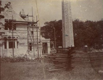
Post World War One, there was little appetite for the renting or purchase of grand mansions. Greenholme Mansion was demolished in 1923.
Much of the materials such as the stone & timber was used to build the properties of Great Pasture. (See 1938 OS Map). These were made available to the senior personnel of Wm Fison & Co. Ltd.
Greenholme Mills & Great Pasture, Burley in Wharfedale. OS Map 1938. Image courtesy of NL Scotland.
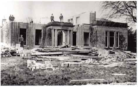
1923 Demolition Greenholme Mansion, Burley in Wharfedale. Image courtesy of Burley Archive
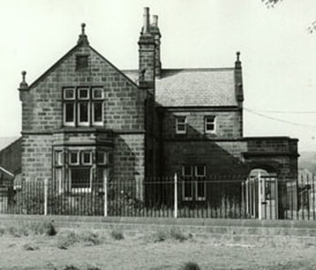
Wharfeside, Leather Bank, Burley in Wharfedale
Wharfeside was built for William E Forster & his wife Jane Martha nee Arnold. Construction started in 1851 & was completed in February 1852.
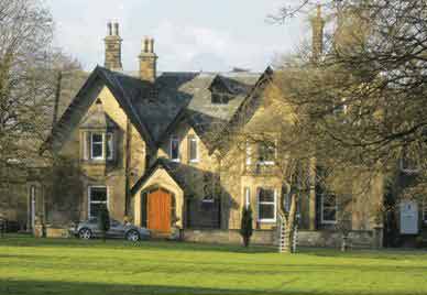
Wharfeside, Leather Bank, Burley in Wharfedale. Image courtesy of thediaryofalondonmarathonvirgin.blogspot.com
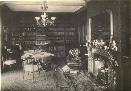
The Library at Wharfeside, Burley in Wharfedale, c1880. Image courtesy of archive.org
1926 Aerial Photographs of Greenholme Mills (1790-1968)
Out of thousands of images, the only 2 photographs of Burley in Wharfedale on the Britain from Above database, are both of Greenholme Mills .
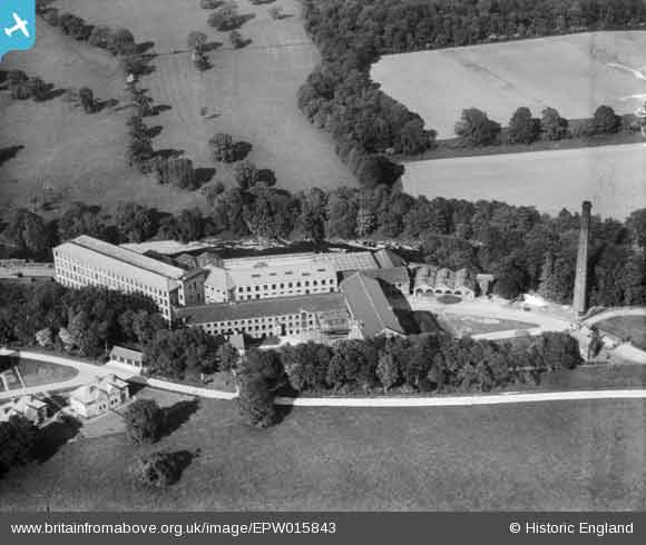
Britain From Above - Greenholme Mills, Burley in Wharfedale, 1926. Image courtesy of Historic England.
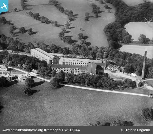
Britain From Above - Greenholme Mills, Burley in Wharfedale 1926. Image courtesy of Historic England.
Bond Aerial Images was asked to reproduce a similar image to the ones above.
The result taken in February 2018 is below.
Our first thought on seeing it, was sadness, what a waste, so much destruction of such an historic site.
Greenholme Mills Industrial Estate had the potential to be a smaller version of Salts Mill, Saltaire or Dean Clough at Halifax.
Now to be just more housing & apartments, with no use made of the goits & the in-situ turbines to generate their own electricity.
For one of the largest water powered mills in the UK such a sad end.
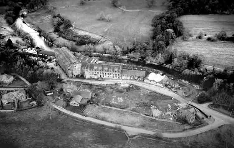
Greenholme Mills, Burley in Wharfedale February 2018. Photo courtesy of Bond Aerial Images.
Burley Community Library & Burley Archive, Grange Road, Burley in Wharfedale, West Yorkshire England LS29 7HD
Opening Times: Monday, Tuesday and Friday 10.00am to 5.00pm, Thursday 2.00pm to 7.00pm, Saturday 10.00am to 1.00pm. Closed Wednesday & Sunday
Burley Archive & Local History Group: Drop-In Sessions Friday 2.30pm to 4.30pm. For other times please contact us
Burley Archive & Local History Group: Drop-In Sessions Friday 2.30pm to 4.30pm. For other times please contact us
